- Home
- Bouddi National Park
Bouddi National Park

Bouddi National Park is a perfect spot for day trips from Sydney or the Central Coast – you can get there easily by car.
It’s located southeast of Gosford.
The park offers a diverse range of landscapes... coastal cliffs, lovely beaches, rainforests and open heathlands.
It's a great place to go hiking while taking in stunning coastal views. You can also swim at one of the secluded beaches.
If it's your first time exploring this park, we'll tell you all about the most popular walks, beaches and lookouts to visit.
Contents
Bouddi Coastal Walk

The Bouddi Coastal Walk stretches for 8.5 km between Macmasters Beach and Putty Beach and takes about 2 - 3 hrs to complete. You can however enjoy shorter sections of the walk (more below).
The difficulty is graded 3 because there are short steep hills. One part of the walk is a little challenging.
The Coastal Walk is the most popular walk not only in Bouddi National Park but on the whole of the Central Coast. It's strenuous in parts but the views are magnificent.
We never tire of it.
You get amazing ocean views almost all the way.
You can do the Coastal Walk in sections. My favourite section is between Putty Beach and Maitland Bay because of the breathtaking scenery.
Hidden Beaches
Maitland Bay

You can get to Maitland Bay via four different walking tracks. They're all great.
- The Maitland Bay track is the quickest way to Maitland Bay (900 m - 30 min). The track begins at the Bouddi National Park Information Centre.
- A bit longer but beautiful is the Mount Bouddi walking track (1.6 km - 45 min) which begins at the end of Mount Bouddi Rd.
- Maitland Bay is also accessible via the Coastal Walk from Putty Beach (3 km) or from Macmasters Beach (5.2 km).
Maitland Bay is an isolated beach and probably the second biggest attraction in Bouddi National Park. It's a truly stunning beach.
Putty Beach

Putty Beach has direct car access. Follow Putty Beach Rd to the end. Parking costs $8.
This beach is popular with families with small children because the water is calm and great for swimming. You can also fish and camp.
The Coastal Walk starts at the end of Putty Beach - walk up the stairs and continue along the boardwalk. It's the best section!
Little Beach

You can get to Little Beach by walking along a trail (700 m) from Grahame Dr in Macmasters Beach. It's a nice stroll through a beautiful remnant rainforest. It's easy to wheel an all-terrain pram.
Little Beach is a secluded cove with a campground. It's a great spot for a picnic. There's a barbecue and non-flush toilets.
The Coastal Walk traverses it.
I've seen many surfers carrying their surfboards there and paddling out.
Lobster Beach

Two walking tracks lead to Lobster Beach:
- The Flannel Flower walking track (1.2 km - 40 min) passes flannel flowers and beautiful views of Pearl Beach and Ocean Beach. Park at the end of Hawke Head Dr in Killcare.
- If you prefer to take a shortcut to Lobster Beach, park on High
View Rd, corner Venice Rd in Wagstaffe. It's a quick walk up and down stairs.
Lobster Beach is an isolated beach in Broken Bay. The beach is peaceful and uncrowded.
Tallow Beach and Little Tallow Beach

The trail that leads to Tallow Beach is steep but short and takes about 30 min (1.2 km).
To get to Tallow Beach, park at the end of Hawke Head Dr in Killcare. Walk past the fence to the end of the trail and take the left track indicated 'Tallow Beach'.
If you're looking for a hidden beach, Tallow Beach is spot on. It's usually empty. I've seen people riding their mountain bike down the trail and carrying surfboards. Along the walk, you'll get elevated views of Tallow Beach backed by sandstone escarpments.
A track also leads to Little Tallow Beach, a tiny beach south of Tallow. You're most likely not going to see a soul there.
Macmasters Beach

Macmasters Beach is not hidden but is a beautiful beach at the southern end of Bouddi National Park. There's a surf lifesaving club with lifeguard patrol and a cafe. The Coastal Walk starts from here.
Park beside the surf lifesaving club.
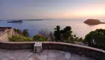
Scenic Lookouts
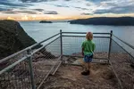
Marie Byles Lookout

Marie Byles Lookout is located along The Scenic Rd between Maitland Bay Dr and Wards Hill Rd. There's an accessible parking area right beside the lookout.
It's a great place to take in the scenery across Broken Bay and Sydney's Northern Beaches.
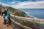
Gerrin Point Lookout

Gerrin Point Lookout is a short stroll from Putty Beach along the Coastal Walk. To get there, climb the stairs at the end of Putty Beach and follow the boardwalk.
You'll get stunning views of Maitland Bay and you may spot migrating whales during the winter months.
Bullimah Spur Track

The Bullimah Spur Track (1 km) begins at the Bouddi National Park Information Centre. It takes you to a magnificent viewpoint that looks over Putty Beach.
You'll walk through a delightful forest filled with Angophora trees
and cycads.
From the lookout, an unofficial track continues down to the Coastal Walk. The track is a little hard to spot but you'll find it at the end of the large rock. You can then do a loop walk via Putty Beach or Maitland Bay.
Box Head

The Box Head walking track (1.5 km - 35 min) leads you to outstanding views of Broken Head and Sydney's Palm Beach.
To get to Box Head, park at the end of Hawke Head Dr in Killcare. Walk past the
fence and down the trail. Follow the sign to Tallow Beach and take
the fork indicated 'Box Head'.
Allen Strom

Walk or ride a mountain bike to Allen Strom Lookout along an easy trail (1 km - 30 min).
To get there, park on Wards Hill Rd, corner Maitland Bay Dr in Killcare Heights. The trail begins a couple of metres down the street.
The Allen Strom Lookout overlooks the beautiful Hardys Bay dotted with sailing boats.
10. Daleys Point

The Daleys Point Trail (1.7 km - 50 min) leads to an Aboriginal engraving site and a great view of St-Hubert’s Island and Brisbane Water.
To get there, park in the carpark on Wards Hill Rd, corner Maitland Bay Dr in Killcare Heights.
The walk is along a trail through dry woodland. You can also ride your mountain bike.
Mountain Biking
Bouddi National Park has about 10 km of well defined trails that are awesome for mountain biking.
A great place to start is at the Bouddi National Park Information Centre. From there, you'll do a loop then head to Allen Strom Lookout and Daleys Point Trail.
If you have small children, stick to a smaller section. The loop and Allen Strom trails are easier and Daleys Point is a bit harder.
Check the map for mountain biking.
Camping
There are three campsites in Bouddi National Park, metres from the beach.
Putty Beach Campground is easy to access by car and sits a few metres from Putty Beach.
Little Beach Campground is beside the ocean and you have to carry your gear along the trail.
Tallow Beach Campground is down a steep trail and has no car access, but you'll probably have the beach to yourself.
Where to Park
There are many entry points in Bouddi National Park with ample parking. Putty Beach is the only spot where you need to pay for parking ($8). You can also park at Macmasters Beach or at the Bouddi National Park Information Centre.
Map

Photos
 Rainbow on the Mount Bouddi walking track
 Aboriginal engravings on the Daleys Point Trail
 View of Tallow Beach from Box Head walking track
 Tallow Beach and Little Tallow Beach
For more information about Bouddi National Park, visit NSW National Parks and Wildlife Service.
You May Also Like
Wyrrabalong National Park Walking Tracks - iCentralCoast
Local's guide to walking in Wyrrabalong National Park. The Coast walking track is a favourite.
8 Best Brisbane Water National Park Walks - iCentralCoast
Walking in Brisbane Water National Park leads you to remarkable places. Experience these 8 great day walks.
8 Best Ku-ring-gai Chase National Park Walks - iCentralCoast
Ku-ring-gai Chase National Park in Sydney makes for a great escape from the city – it offers great bushwalking and idyllic beaches.
* As an Amazon Associate, I earn from qualifying purchases.
* Amazon and the Amazon logo are trademarks of Amazon.com, Inc. or its affiliates.
Copyright © 2016-2026, iCentralCoast | All rights reserved. | Privacy Policy & Disclaimer
Site by The Phoenix Digital